|
A volcanic lake with many 'mysteries'
 From the encounter
of magma spewed from the
depths of the earth and the water
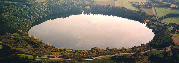
present in the region's subsoil, the Tazenat crater lake was
born. This was 40,000 years ago. A gigantic scar located at
the northern end of the Chain ("gour" is synonymous
with chasm), it is now a
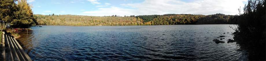
magnificent lake considered one of the most beautiful in Auvergne.
It represents the perfect example of a phreatomagmatic explosion
maar, characterized by its geometry
and its peripheral deposits, which tell the story
of its genesis. It is also the site (along with Lake Pavin at
the southern end of the chain) that has the most legends
and mysteries, no doubt because it has always intrigued
the local people. Its depth remained unknown for a long time:
it was suspected to connect with the sea!!! And then there are
those demons that haunt it at night... In any case, its clear
waters and setting make it a pleasant site highly
visited by tourists. From the encounter
of magma spewed from the
depths of the earth and the water
present in the region's subsoil, the Tazenat crater lake was
born. This was 40,000 years ago. A gigantic scar located at
the northern end of the Chain ("gour" is synonymous
with chasm), it is now a
magnificent lake considered one of the most beautiful in Auvergne.
It represents the perfect example of a phreatomagmatic explosion
maar, characterized by its geometry
and its peripheral deposits, which tell the story
of its genesis. It is also the site (along with Lake Pavin at
the southern end of the chain) that has the most legends
and mysteries, no doubt because it has always intrigued
the local people. Its depth remained unknown for a long time:
it was suspected to connect with the sea!!! And then there are
those demons that haunt it at night... In any case, its clear
waters and setting make it a pleasant site highly
visited by tourists.
|
|
|
|
An explosion crater
of considerable dimensions: 65 meters deep, 700 meters in diameter
|
| |
|
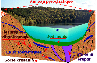
Some magma and water
 |
|
coupe du cratère
|
The contact of magma with water coming from infiltrations
through cracks in the bedrock is the origin of the so-called
phreatomagmatic explosions.
The water is vaporized during the mixing with the hot magma.
The vapor pressure then violently opposes the hydrostatic pressure,
which depends on the depth of the phenomenon. The result is
an explosion directed along the eruptive conduit that
fragments the substrate, expelling its materials
as well as volcanic elements. The crater gradually forms by
the collapse of the gaping
cavity. The deposits fall back to the periphery, according to
the direction of the trajectories and the winds for the lighter
ones. In the case of the Tazenat crater, the continuous supply
of magma and water gave a rhythmic
character to the explosions. The cycles cease as soon as one
of the components disappears.
|
|
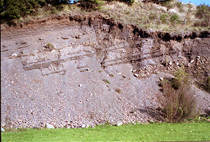 The
deposits of the pyroclastic ring
are organized in layers (see photo
of the quarry), from which one can deduce the nature
of the successive explosions that formed it. Mixed together
are fragments of the bedrock, granites, microgranites, Viséan
tuffs, and basaltic fragments from the eruption. Often, the
basalt blocks contain inclusions of crystalline rocks, laminated
during ejection. 70% of the deposits come from the bedrock. The
deposits of the pyroclastic ring
are organized in layers (see photo
of the quarry), from which one can deduce the nature
of the successive explosions that formed it. Mixed together
are fragments of the bedrock, granites, microgranites, Viséan
tuffs, and basaltic fragments from the eruption. Often, the
basalt blocks contain inclusions of crystalline rocks, laminated
during ejection. 70% of the deposits come from the bedrock.
The lake is largely fed by the
hydrographic network existing in the cracks of the basement.
The bottom, where the water temperature is 4 to 5°C, is composed
of lake sediments covering
the debris of the explosive crater.
|
Visit
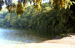 The discovery of
the site is simply done by going around
it. Right away, one will notice the very steep slopes
of the crater, imagining its extension into the water, which
gives an idea of the power of the elements. It is from the north
and east sides that one has the best
perspective on the lake, on the Puy de Chalard to
the southwest, and on the Chaîne des Puys to the south. Descending
back towards the road to Charbonnières-les-Vieilles, veer towards
the quarry, which thus provides a cross-section in the pyroclastic
ring. Notice the strata and the rocks that compose it. The discovery of
the site is simply done by going around
it. Right away, one will notice the very steep slopes
of the crater, imagining its extension into the water, which
gives an idea of the power of the elements. It is from the north
and east sides that one has the best
perspective on the lake, on the Puy de Chalard to
the southwest, and on the Chaîne des Puys to the south. Descending
back towards the road to Charbonnières-les-Vieilles, veer towards
the quarry, which thus provides a cross-section in the pyroclastic
ring. Notice the strata and the rocks that compose it.
In summer, the coolness of the
place invites lingering in the shade of the undergrowth. This
area, fairly well preserved, attracts many tourists seeking
a bit of tranquility by
the lake.
|
|
|
|