|
|
To each lord, all honor
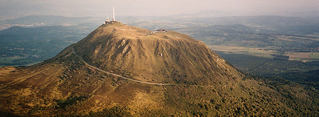
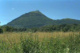
 It's the star of this overview. An iconic
mountain of Auvergne, it gave its name to the department
(the officials at the time had considered 'Monts Dore,' but, in
true Auvergnat fashion, that sounded too fancy). The Giant of
the Dômes, from the Romans
to Pascal, and even the cycling
duo Anquetil-Poulidor, is
truly a star. Besides, it can be seen from far away: its high
altitude compared to the surrounding plateaus makes it a legendary
mountain. On foot, on horseback, by steam, by bike, by car, and
now thanks to the Panoramique
des Dômes, the rack railway, it makes you want to climb it.
And it's tempting, because at its summit, it offers an exceptional
view. It's the star of this overview. An iconic
mountain of Auvergne, it gave its name to the department
(the officials at the time had considered 'Monts Dore,' but, in
true Auvergnat fashion, that sounded too fancy). The Giant of
the Dômes, from the Romans
to Pascal, and even the cycling
duo Anquetil-Poulidor, is
truly a star. Besides, it can be seen from far away: its high
altitude compared to the surrounding plateaus makes it a legendary
mountain. On foot, on horseback, by steam, by bike, by car, and
now thanks to the Panoramique
des Dômes, the rack railway, it makes you want to climb it.
And it's tempting, because at its summit, it offers an exceptional
view.
|
|
|
|
Seen
from above, the Puy de Dôme shows a western dome that must have
been perfect
|
 > |
|
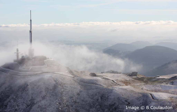
And
when "la burle" blowes on the top
|
A 10,000-year-old youngster
It's its age. It's little compared to the first
buildings of the Chain (100,000 years). Before its formation,
the few inhabitants of the Limagne plain near Clermont observed
in its place a modest Strombolian scoria
cone. Not enough to put up a television antenna. The
western profile of the Clermont horizon was, of course, very different.
Its construction and the history of events can be summarized as
follows.
It is in the initial Strombolian
cone that a first trachyte dome
is born and likely built. Trachyte is
a very viscous lava that does not flow but remains
directly over the vent. The development experienced no major incidents,
and the altitude approached
exceptional values for this
type of volcanic activity. During this phase, pyroclastic flows
of limited extent covered the surrounding areas, scorching the
nearby forests. The dome is almost perfect, comparable to the
dome of La Soufrière in Guadeloupe (also worth seeing).
The building could have remained
as it was, but a collapse,
possibly resulting from an explosion, opened up the eastern part.
The growth of the dome continues in the
collapsed section. A progression similar to the first,
but sharper, which will give it the characteristic shape we see
today. It is referred to as a Pelean
dome, with the point of comparison being Mount
Pelée in Martinique, which apparently underwent the
same growth scenario (resulting in the destruction of the town
of Saint Pierre). But the comparison ends there, as the dome of
Mount Pelée is a summit dome of a stratovolcano
with very different lavas from a subduction context.
The surrounding area is covered,
on one hand, by deposits from pyroclastic
flows emitted during the formation phase, and, on the
other hand, by fragments from the eastern part. Vegetation then
gradually colonizes the region, until the later occurrence of
side events, such as the eruption of
Puy Kilian about 8,500 years
ago, which covered Puy de Dôme with pyroclastic materials.
Does this episode mark the end of volcanic
activity in the central area of the Chaîne des Puys?
|
|
Relief
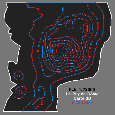
The Puy de Dôme remains
the highest volcano in the Chaîne des
Puys at 1,465 meters. Its ascent has been made since
Roman times via the Muleteers' Path
on its southwest face. In 1907, a steam
cogwheel tram allowed the people of Clermont to effortlessly
climb the giant of the domes from the city. The development of
the automobile led to the disappearance of this means of access,
and the route was converted into a road
for cars in the mid-20th century. This path makes a
one and a quarter tour around the volcano with a steady 12% incline.
Ironically or as a sign of changing times, the road has been abandoned
since 2012 in favor of a new electric
cogwheel train. This original solution, initiated by
the General Council, allows the widest audience to discover this
emblematic summit while preserving the
environment.
The hike
up the Muleteers' Path is
still an enjoyable experience. Starting from the Col de Ceyssat,
the path climbs 400 meters in elevation, offering a wide panorama
of the southern volcanoes and the Sancy
Massif. The round-trip can take between 2
to 4 hours, depending on the pace you set for yourself.
By looking at the 3D map
with a pair of 3D glasses (right-eye filter: blue; left-eye filter:
red), you will get a unique view of the
Puy de Dôme. If you don't have any, you can make
a pair using transparent paper in the indicated colors, or order
your glasses .
Equipped in this way, look directly at the screen from about 0.5
meters away (or print the map). .
Equipped in this way, look directly at the screen from about 0.5
meters away (or print the map).
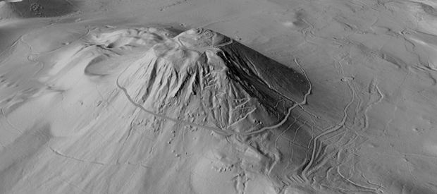
But today's Lidar image (Source
Géoportail) is even
more striking.
|
|
|
|
Lavas types
The Puy de Dôme did
not produce lava flows, except for pyroclastic flows and
fallout, ash, and boulders ejected during the growth of
the dome and its collapses. The lava is a trachyte
which, when cooling, produces a white
and friable rock. The lava of Puy de Dôme was
long called Dômite.
The rock's matrix contains phenocrysts (large crystals)
of black biotite (mica) and quartz. Its silica content (SiO2),
one of the highest at 65%, is a testament to the final
evolution of the magmas of the Chaîne des Puys.
|
|
|
Science and the Puy de Dôme
On September 19, 1648, the summit
was the scene of Blaise Pascal's
experiment, who, using Torricelli's barometer, demonstrated
the variation of atmospheric
pressure with altitude. It was his brother-in-law,
Mr. Perrier, who carried out the operation. The story
goes that Pascal never climbed the Puy de Dôme for
fear of being suffocated. In fact, he was ill, and
because of this, he had entrusted the work to his
brother-in-law.
|

Atmospheric
pressure as a function of altitude
|
|
|
|